
Search london history from Roman times to modern day
St Magnus Martyr pub history index

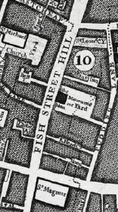
The John Rocques Map of London in 1756 clearly marks the Star Inn, the Swan and Monument Yard.
A listing of historical London public houses, Taverns, Inns, Beer Houses and Hotels in St Magnus Martyr parish, City of London.
Residents at this address
The 1682 Morgans Map of London lists 636 Starr Inne; set between New Fish street and Pudding lane.
In 1708 : A New View of London by Edward Hatton describes the Star Inn on the east side of New fish street hill, a passage to Pudding lane.
The John Rocques Map of London in 1756 marks the Star Inn, the Swan and Monument Yard.
The John Rocques Map of London in 1799 suggests the Star Inn was at about 42 Fish street hill
Trying to avoid privacy and cookie settings overwriting content