
Search london history from Roman times to modern day
It has had its share of different communities over time , the Hugeonot settlers, then the Jewish community and now the bengali community. You can view maps and pictures, both old and new. But, the best way to describe an area over time is through its Pubs and its people who lived there. These pages are a time line of Brick Lane over approximately a two hundred year time zone, using the East London Pubs as markers along the way. A virtual pub crawl in time!

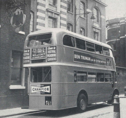
A bus is an unusual site in Brick lane, in 1952; along with its Trumans advertising panels
Kindly provided by Alex Wilkinson
As roads are renamed over time, I will use a modern day look of Brick Lane in 1915 to describe the route as Brick Lane runs north, from Whitechapel High Street, originally as part of Osborne Street, along Brick lane, and runs up to Bethnal Green Road (originally called Church Street in the 1850s) and then continues north to Virginia Row/Street. Just compare the maps. The listings are from the following trade directories: 1839 Pigots, 1841, 1851, 1856, 1882, 1895, 1899 & 1915 Post Office.
East side of Brick Lane (Starting at 1 Brick Lane)
2 - 40 Brick Lane (or 1 - 20 Brick Lane for 1882 and earlier) - From Osborne Street to Osborn Place.
40 - 104 Brick Lane ( or 20 to 41 Brick Lane for 1882 and earlier) - From Osborne Place to Booth Street,
106 - 138 Brick Lane (or 49 to 63 Brick Lane for 1882 and earlier) - From Booth street to Pelham Street
140 - 180 Brick Lane (or 63 to 109 Brick Lane for 1882 and earlier) - From Pelham Street to Hare Street
182 - 226 Brick Lane (or 110 to 132 Brick Lane for 1882 and earlier) - From Hare Street to Bethnal Green Road
230 to 272 Brick Lane (plus all of Tyssen Street for 1882 & earlier) - From Bethnal Green Road to Ducal Street -
274 to 324 Brick Lane (plus all of Turks Street for 1882 & earlier) - From Ducal Street to Columbia Road
West side of Brick Lane (Starting at Brick Lane)
1 to 39 Brick Lane ( 194 to 211 Brick Lane for 1882 and earlier) - From Osborne Road to Fashion Street
41 to 79 Brick Lane ( 180 to 193 Brick Lane for 1882 and earlier) - From Fashion Street to Hanbury Street
81 to 117 Brick Lane ( 156 to 174 Brick Lane for 1882 and earlier) - From Hanbury Street to the Sclater Street
125 to 161 Brick Lane ( 136 to 156 in 1882 and earlier - in reverse direction) - From Sclater Street to Bethnal Green Road
167 to 207 Brick Lane ( not in 1882 and earlier - in reverse direction) - From Bethnal Green Road to Boreham Street
213 to 305 Brick Lane ( not in 1882 and earlier - in reverse direction) - From Boreham Street to Virginia Road
For Tyssen Street and Turk street - see entries for east side of road.
Trying to avoid privacy and cookie settings overwriting content