
Search london history from Roman times to modern day
Westminster St Margaret pub history index
[A note about King street, which runs north - south and is joined by the newer Parliament street by 1743 running alongside to the east.]
It must be remembered that there was then no Parliament Street, and the palace buildings occupied all the ground from Old Scotland Yard to Downing Street, from St. James's Park to the river.
When Parliament Street was made it effaced Clinker's Court, White Horse Yard, Lady's Alley, Stephen's Alley, Rhenish Wine Yard, Brewers' Yard, and Pensioners' Alley—some of the slums which had sprung up outside the Abbey precincts. Now Parliament Street in its turn is effaced, swallowed up in an extended Whitehall. King Street has been completely swept away, as one sweeps a row of crumbs from a cloth, but the part it played in the ancient history of Westminster is not yet forgotten.
Parliament Street and King Street have now been merged in one, and together have become a part of Whitehall, so that the very names will soon be forgotten. Yet King Street was once the direct land route to the Abbey and Palace from the north, and its narrow span was perforce wide enough for all the pageantry of funerals, coronations, and other State shows that passed through it. It must be remembered that King Street formerly ran right up to the Abbey precincts, from which it was separated by a gate-house, called Highgate, built by Richard II.

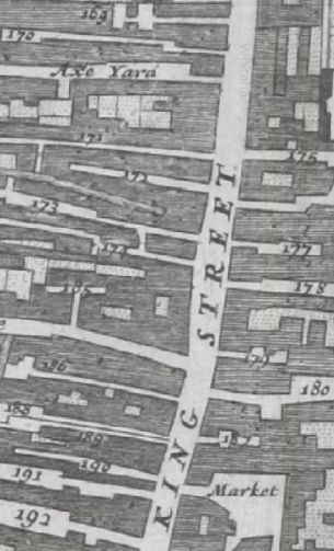
In the Morgans 1682 Map of London in King street are isted '180 White horse Inne' and 173 Rose & Crown Inne.
Also listed in 1682 are 169 Hamlins yard, 170 Duffins alley, Axe Yard, 171 Sea alley, 172 Bell Court, 173 Rose & Crown Inne , 174 Chequer alley , 185 Poulterers yard , 186 Pewterers alley, 188 Faulcon alley , 189 Smiths alley , 190 Antelope alley, 191 Blew boar Inne and 192 George yard
and on East side are 175 Pentioners alley, 177 Rhenish wine yard , 178 Stephens Lane , 179 Lady Court, 180 White horse Inne and 181 Bracebys alley

In the John Rocques 1746 Map of London, King street has been joined by the building of new Parliament street. Downing street can also be seen at the top end of King street.
Historical London public houses, Taverns, Inns, Beer Houses and Hotels.
Residents at this address
In the Morgans 1682 Map of London in King street are listed '180 White horse Inne' on the East side, and almost opposite Gardiners lane.
In 1708 : A New View of London by Edward Hatton lists White horse inn, on the East side of King street, Westminster, being toward the South end.
John Strype Survey of London in 1720 - Parish of St Margaret, Westminster lists '11 White horse yard', which is on the East side of King street.
In the John Rocques 1746 Map of London, King street has been joined by the building of new Parliament street. Downing street can also be seen at the top end of King street.
Trying to avoid privacy and cookie settings overwriting content