
Search london history from Roman times to modern day
Southwark St Saviour pub history index
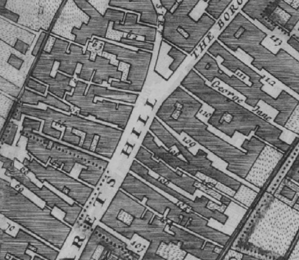
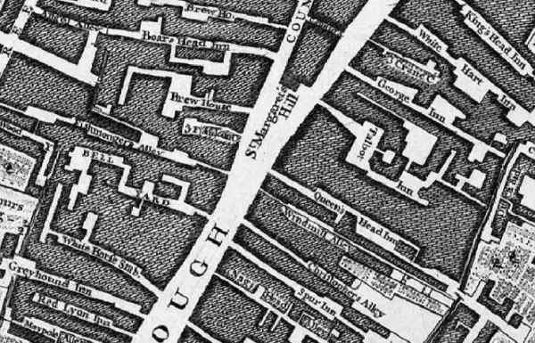
The Morgans map of 1682 cofirms the existence of the Greyhound Inne at that time. This is marked as "Greyhound Inn" on Rocque's map of 1746, as a yard running between Borough High Street and Queen Street (later renamed as part of Union Street), forming the eastern stretch of Union Street. An 1809 Sun Fire Office insurance record notes it is on the south side of Queen Street in the parish of Southwark St Saviour, meaning it was west of the parish boundary (which crossed Union Street approximately halfway along the stretch between modern Borough High Street and Redcross Way). *

Borough High Street in the Morgans map of 1682. On east side are 113 Kings Head Inne, 112 White Hart Inne, 111 Three Crown court, George Inne, 110 Talbot Inne, 109 Queens head Inne, 108 Cock & hoop alley, 107 Windmill alley, 106 Christopher alley , 105 Spurr Inne. On west side are 62 Malings yard, 63 Saints alley, 64 Great yard, 65 Fishmongerv alley, 66 Bell yard, 67 Windmill alley, 68 Whitehorse Inne, 69 Greyhound Inne, 70 Maypole alley.

Borough High Street in 1746. On east side are Kings Head Inn, White Hart Inn, Three Crane court, George Inn, Talbot Inn, Queens Head Inn, Windmill alley, Christopher alley, Spur Inn, Nags Head alley. On west side are Boars Head Inn, Brewhouse, Fishmongers alley, Bell Yard, White Horse stables, Greyhound Inn, Red Lyon Inn, Maypole alley.
A listing of historical London public houses, Taverns, Inns, Beer Houses and Hotels in Southwark St Saviour, Surrey, London.
Residents at this address.
1748/Gilbert Clarke/innholder, Greyhound Inn/../../Prerogative Court of Canterbury wills and probate records held at the National Archives *
1768/Joseph Morgan/innkeeper/../../Surrey Quarter Sessions records held at the Surrey History Centre *
1793/James Cockcroft/victualler/../../Sun Fire Office records held at the London Metropolitan Archives *
* Provided By Ewan
Trying to avoid privacy and cookie settings overwriting content